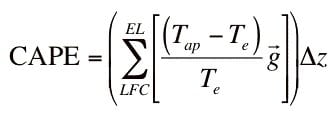
CAPE represents the amount of buoyant energy available to accelerate a parcel vertically, or the amount of work a parcel does on the environment. The higher the CAPE value, the more energy available to foster storm growth. CAPE is especially important when air parcels are able to reach the Layer of Free Convection (LFC). To find CAPE from a skew-T thermodynamic diagram simply locate the area on the diagram where the parcel sounding (light green line) is warmer or farther to the right than the atmosphere sounding (red line). This corresponds to the white shaded region on the sounding below:
 |
 |
The white region is called the “positive energy” region. This area of this region is CAPE in Joules/kg. Naturally, the larger this area, the more CAPE, and the more energy that is available to rising parcels.
The chart below can be used objectively to gain a greater understanding of what numerical values of CAPE inidcate as it relates to convection of air parcels. A current map displayling CAPE across the country can be seen here.
| CAPE value | Convective potential |
| 0 | Stable |
| 0-1000 | Marginally Unstable |
| 1000-2500 | Moderately Unstable |
| 2500-3500 | Very Unstable |
| 3500+ | Extremely Unstable |
It is important to remember that CAPE represents potential energy, and will only be used should a parcel be lifted to the level of free convection.
Courtesy of Ohio State University, http://twister.sbs.ohio-state.edu/helpdocs/cape.html.