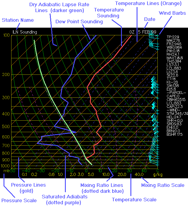
Description of Terms
- TP = Tropopause Height (mb)
- MW = Height of maximum wind level (mb)
- FRZ = Lowest freezing level (mb) or BG if below ground
- WB0 = Height of Wet Bulb zero (mb) or BG if below ground
- PW = Precipitable Water (in)
- RH = Mean relative humidity (%) from the surface to 500 mb
- MAXT = Est. maximum temperature (C) using a 150 mb layer
- TH = 1000-500 mb thickness (m)
- L57 = 700-500 mb lapse rate (C/km)
- LCL = Lifting condensation level (mb)
- LI = Lifted Index (C) using 100 mean layer above surface
- SI = Showalter Index (C)
- TT = Total Totals Index
- KI = K Index
- SW = Sweat Index
- EI = Energy Index
Parcel Derived Quantities (yellow line on soundings)
- CAPE = Convective Available Potential Energy
- CINH = Convective Inhibition (open ended)
- LCL = Lift condensation level (mb)
- CAP = Cap strength (C)
- LFC = Level of Free Convection (mb)
- EL = Equilibrium level (mb)
- MPL = Maximum parcel level (mb)
Wind Parameters
- STM = Estimated storm motion (kts) from 0-6000m AG mean layer, spd 75% of mean, direction 30 degrees veer from mean
- HEL = Storm relative helicity 0-3000m AG (total value)
- SHR+ = Positive shear magnitude 0-3000m AG (sum of veering shear values)
- EHI = Energy helicity index (proportional to positive helicity * CAPE)
- BRN = Bulk Richardson number 500-6000m AG (proportional to CAPE/ bulk shear)
- BSHR = Bulk shear value (magnitude of shear over layer)
Source: The Ohio State University Atmospheric Sciences Program